The Committee on Climate Change predicts that flooding is one of three risks to cities from climate change in the UK. Flooding can result in loss of life and significant damage to property; something we have all seen with extreme events throughout the UK. Part of the Data Assimilation for the REsilient City (DARE) research project at the University of Reading is looking at how to improve flood forecasting using data assimilation techniques. Data assimilation describes the process by which measurements of the real world are combined with previous forecasts from a computer model to produce an improved forecast.
Rivers are not as well monitored as the atmosphere, and part of the DARE project is looking at how to exploit so-called “data sets of opportunity” – existing sources of information that can be included in a predictive model without expensive outlay on instruments. One example of this is a network of video cameras that monitor rivers for leisure purposes such as fishing and tourism. On 16th April, a team from the University of Reading conducted a field trip to test whether it is possible to extract high quality information about river height and water content from this type of camera image.
The method is quite straightforward: from the camera images, fixed points of different heights that can be clearly seen are identified e.g. bollards, steps, lock gates, fences. If the heights and locations of these can be accurately measured, then by seeing which features are covered in the images it will hopefully be possible to calculate the height of the river at any given time.
Our destination was Tewkesbury, which has historically suffered from lots of significant floods (including in 2006 and 2012). It is located where the Avon and Severn rivers join, both of which have a number of river camera sites that were in place before the serious floods of November/December 2012. This flood event will be used as a case study to determine how whether information derived from the river cameras is suitable to be used to produce forecasts. The team visited 5 sites along the two rivers to take measurements.
As someone who hasn’t done any fieldwork, this was a very interesting insight into how challenging it is! All of the instruments needed to be leveled using tiny spirit levels, which is much more difficult than it seems. The instruments are also very top heavy, meaning that gusts of wind can unbalance them or cause the satellite link to drop off. It was also fascinating to speak to camera owners, and hear about their experiences of the flood events. This extra contextual information helps to remind you about the potential impacts of the science you are doing, as well as putting in perspective the effects of extreme flooding events for members of the community.

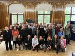
The combined group from Reading and Lancaster

Field work isn’t all hard work!

Leveling the equipment is definitely the trickiest part.

Taking measurements using the Total Station
Reported by: Jemima M. Tabeart who is an NCEO-funded PhD student at the University of Reading on the Maths of Planet Earth Centre Doctoral Training